
As disturbingly encountered this week, a glacier collapsed in Tibet, triggering a flood that rampaged through Nepal, and the resultant river surge threatening Indian states – all a result of climate-induced cryospheric shifts in the Himalayan region. With hundreds dead and thousands missing, from different nationalities, what made this disaster consequential is not just its scale and a reminder of vulnerable geographical landscapes, but also the unravelling of new dimensions of human and climate insecurities, including questions of mobility, infrastructure and disaster diplomacy. It raised questions over developmental paradigms for the Himalayas, particularly not about whether infrastructure is essential but whether it could survive mountain physics. Besides rethinking engineering standards, the imperative is for Himalayan nations to develop cooperative mechanisms for disaster management that transcend national borders and foreign policies. When the mountains move again, these nations should be ready, reminds Professor Swaran Singh in this 30th edition of Asia Watch.
Home page image: The lake that spilled over and caused the flash floods; photo credit - Nepali Times
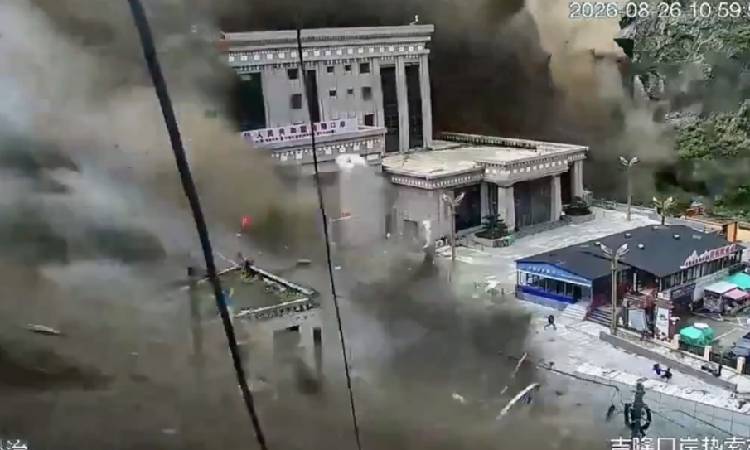
Text page image: A video grab of the floodwaters gushing into the Gyirong Land Port
Banner image: The winding road below Shingo La in Lahaul in Himachal Pradesh that connects with Zanskar in Ladakh; photo credit - Timothy A Gonsalves
On August 26th, the Himalayas ceased to look like the immovable geography on which generations of Asian political and economic planning have been based.
A massive high-altitude ice-and-rock collapse triggered a chain of events in the Tibet-Nepal border region: a landslide and debris avalanche, temporary river blockage, a sudden release of water, and a destructive flash flood that raced through the Lhende Khola, Bhote Koshi and Trishuli river systems.
A large number of bridges, roads, hydropower stations and entire stretches of mountain infrastructure and human habitats were swept away within minutes.
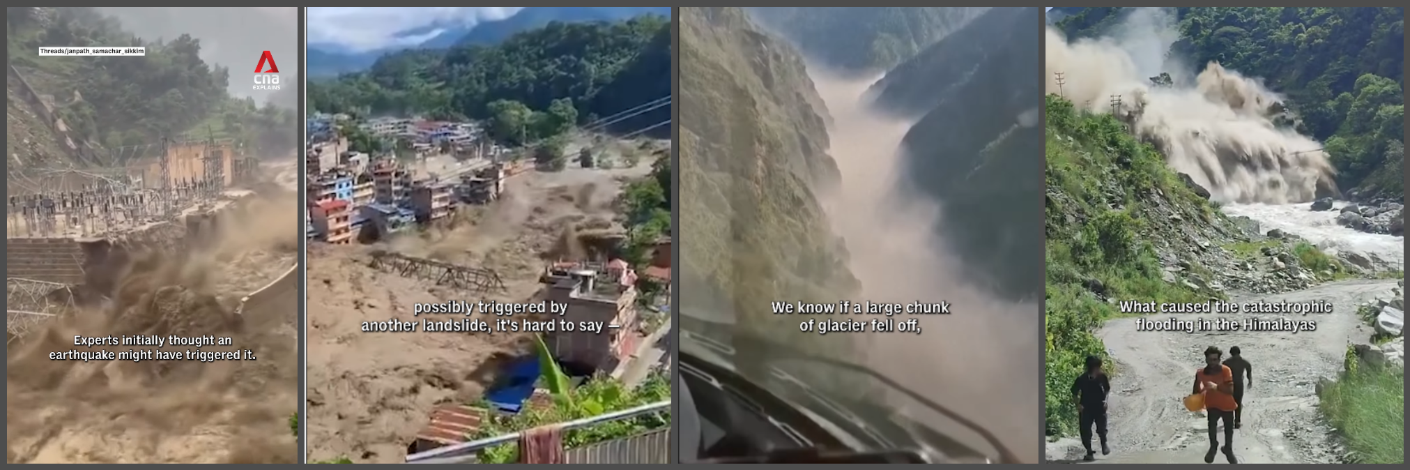
TV visuals (from CNA) of how the disaster unfolded in the foothills and valleys on the Tibet-Nepal border
What makes this catastrophe especially consequential is not simply its scale but its geography. The physical event began in the high Himalayas, crossed administrative and national boundaries, and produced consequences hundreds of kilometres downstream, including in the Indian provinces of Bihar and Uttar Pradesh.
Nepal became the principal theatre of destruction, while Tibet also suffered major losses. The Trishuli River eventually feeds the Narayani/Gandak system, bringing the disaster directly into India’s hydrological and security calculus. This, of course, also saw India engaged as the first mover in Nepal’s relief and rescue operations.
The numbers have continued to rise dramatically since the first reports. By August 28th, Nepal’s disaster authorities had reported more than 600 deaths and close to 3,000 missing, while China reported five deaths and 558 missing in Tibet. More than 3,700 people had been rescued in Nepal.
The figures should not be mechanically added because the datasets are compiled by different authorities and may overlap, but they convey the scale of an unfolding regional tragedy involving three countries.
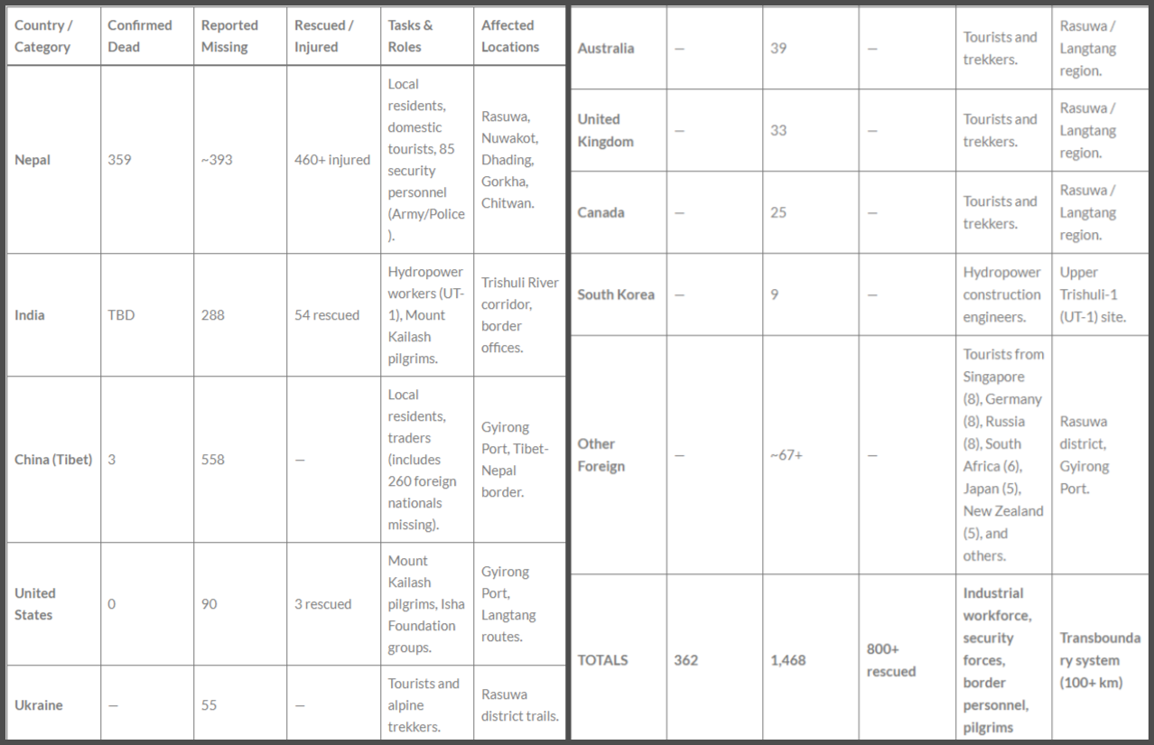
The casualty figures (nationality-wise) aggregated by the South Asia Network on Dams, Rivers and People (SANDRP) on August 28, 2026
A borderless disaster
The international dimension is equally striking. Nepal’s Foreign Ministry reported 632 foreign nationals initially identified in the affected Bhote Koshi area, of whom 121 had been found, and 511 remained missing as of 28 August. These included nationals of more than 30 countries.
The largest reported groups included those from India, China, the United States, Ukraine, Malaysia, Australia, Britain, Canada and so on. While Nepal and China have released territorial death tolls, other governments have not yet established a reliable nationality-wise breakdown of fatalities, though some numbers are being cited in various reports.
This distinction matters: a missing person is not necessarily dead, and the lists are changing as rescue teams reach remote, isolated settlements and stranded travellers. Also, these figures are a snapshot rather than a final casualty register.
India’s Ministry of External Affairs (MEA) subsequently reported that approximately 320 Indian nationals remained missing or untraced, illustrating why national government lists can differ substantially from Nepal’s initial nationality-based register.
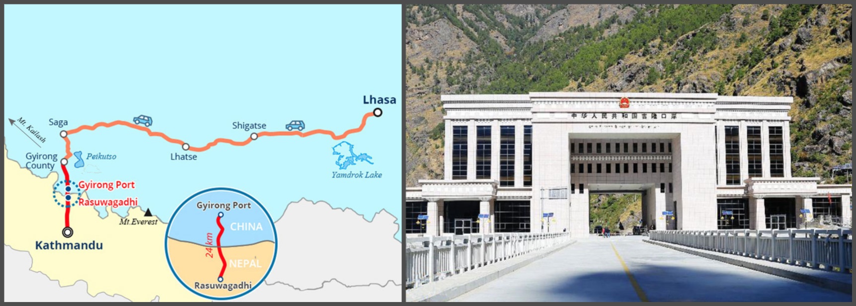
The location of the Gyirong Land Port on the map and an earlier picture of the customs point through which the Kailash Manasarovar pilgrims enter Tibet
The distinction is particularly important for India. Indians were not merely tourists passing through Nepal. Many were undertaking the Kailash Mansarovar pilgrimage, while others were working on hydropower projects.
The MEA informed that while roughly 400 Indian pilgrims stranded on the Chinese side had been contacted and were safe, 149 subsequently crossed from China into Nepal.
The disaster therefore exposes this new dimension of climate insecurity: mobility. Climate-vulnerable landscapes now increasingly include global tourism, pilgrimage and infrastructure corridors.
Disaster diplomacy can no longer be designed solely around populations permanently resident in a territory but must consider human mobility into regions that present an evolving geological reality where warming of glaciers can trigger such catastrophe.
Its geopolitical impact also needs to be assessed and addressed in time.
A compounded hazard
It would be analytically inadequate to describe this event simply as a flash flood. The disaster instead demonstrates the logic of compounding and cascading hazards.
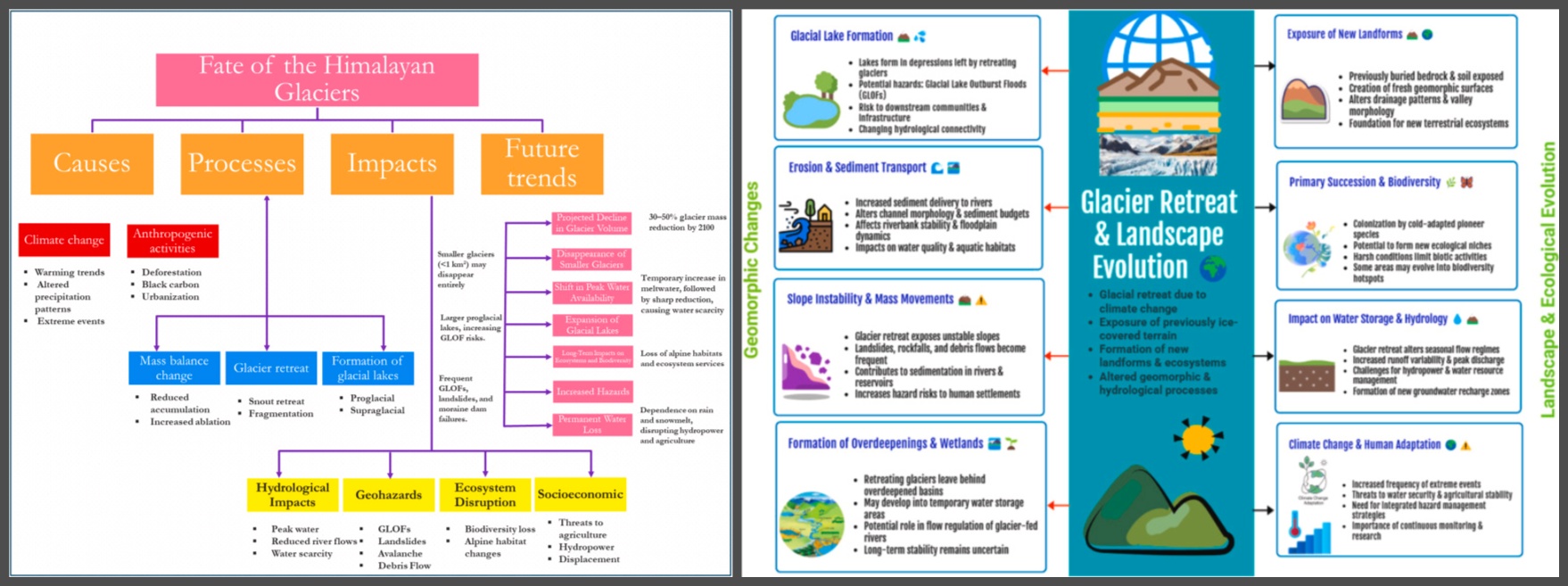
A warming atmosphere accelerates glacier and snow loss. Changes in permafrost and freeze-thaw cycles can destabilise mountain slopes. Heavy precipitation can mobilise loose sediment. Glacial lakes and temporary landslide dams can store enormous quantities of water before failing suddenly.
Human infrastructure then amplifies the consequences: roads concentrate settlement, bridges become points of failure, hydropower projects occupy narrow valleys, and towns expand along rivers.
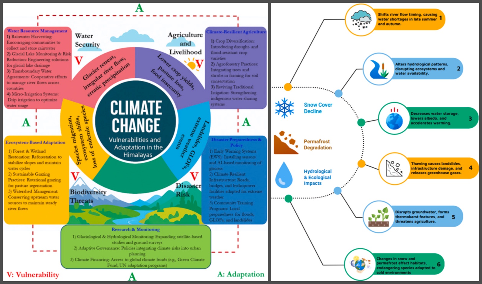
Illustrations from a research paper on Himalayan Glaciers by Rayees Ahmed
The central question is no longer whether the Himalayas should be developed but whether inherited infrastructure assumptions remain valid under rapidly changing mountain physics. This is where the climate-security argument becomes stronger than a conventional environmental argument.
Climate change does not need to generate a single dramatic ‘climate disaster’ to create insecurity. It can alter the probability, timing and sequencing of hazards.
The danger lies in interaction: glacier instability produces a flood; the flood destroys a bridge; the bridge failure isolates communities; isolation delays rescue; infrastructure damage disrupts electricity and communications; and displaced populations become vulnerable to disease and livelihood loss.
The Himalayas are therefore becoming less predictable not necessarily because every individual disaster can be attributed directly to climate change, but it is so because the baseline physical conditions under which risk is calculated are changing.
Not a ‘far away’ crisis
For India, the most important lesson is geographical rather than diplomatic: the Himalayan watershed does not end at the international boundary.
The Trishuli-Narayani-Gandak river systems connect the Nepalese disaster zone to India’s downstream plains. Floodwaters and debris can, therefore, move from a high-altitude catastrophe into densely populated areas of Bihar and Uttar Pradesh.
Indeed, the current disaster has already produced downstream consequences in India, with bodies reportedly recovered in the Gandak system in Uttar Pradesh. This creates at least four distinct Indian vulnerabilities.
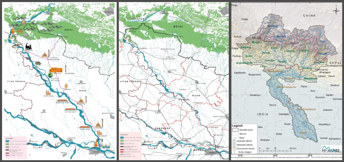
The Narayani-Gandak river system on the map; image source - Living Waters Museum
First is human security. Communities in Bihar and Uttar Pradesh are exposed to sudden changes in river levels and downstream flows. The opening of barrage gates and emergency river management can reduce upstream pressure while simultaneously creating difficult downstream trade-offs.
Second is infrastructure security. India’s own Himalayan states — particularly Uttarakhand, Himachal Pradesh, Sikkim and Arunachal Pradesh — contain roads, bridges, tunnels, hydropower facilities and strategic infrastructure exposed to similar compound hazards.
The 2021 Chamoli disaster and the 2023 South Lhonak glacial-lake outburst in Sikkim already demonstrated India’s exposure to cascading mountain risks.
Third is strategic infrastructure. Mountain roads and hydropower projects are not merely economic assets. In India’s border regions, they are also instruments of strategic connectivity. If climate-induced hazards repeatedly damage such infrastructure, the consequences extend to defence mobility, border management and regional economic integration.
Fourth is citizen protection abroad. The Nepal disaster demonstrates the growing importance of climate-oriented consular diplomacy. Hundreds of Indian citizens were in the affected region for pilgrimage, tourism or employment. The traditional consular model — passports, visas and assistance after arrest or death — is insufficient for an era in which extreme events can suddenly isolate hundreds of citizens.
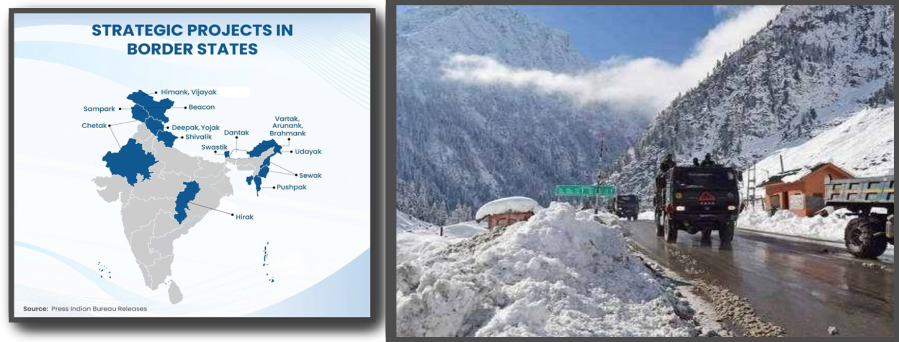
The strategic roads projects of the Border Roads Organisation on the map (left) and a BRO road in Uttarkashi (right); photo credit - IndiaInfraHub
India’s disaster diplomacy
India’s immediate response has already demonstrated several elements of what could become a more systematic regional disaster diplomacy. Prime Minister Narendra Modi spoke to Nepal’s Prime Minister Balendra Shah on 26 August, conveyed condolences and reaffirmed India’s readiness to provide humanitarian assistance.
Indian teams began coordinating with Nepalese authorities on rescue and relief. The Ministry of External Affairs established a 24-hour control room to trace affected Indians and coordinate with the Indian Embassy in Kathmandu and authorities in Nepal and China.
India has also moved beyond diplomatic assurances. It dispatched 10 tonnes of humanitarian assistance on 26 August, followed by another 37.5 tonnes on 27 August, and a further 10-tonne consignment on 28 August, including generators, food, water-purification tablets and other relief material.
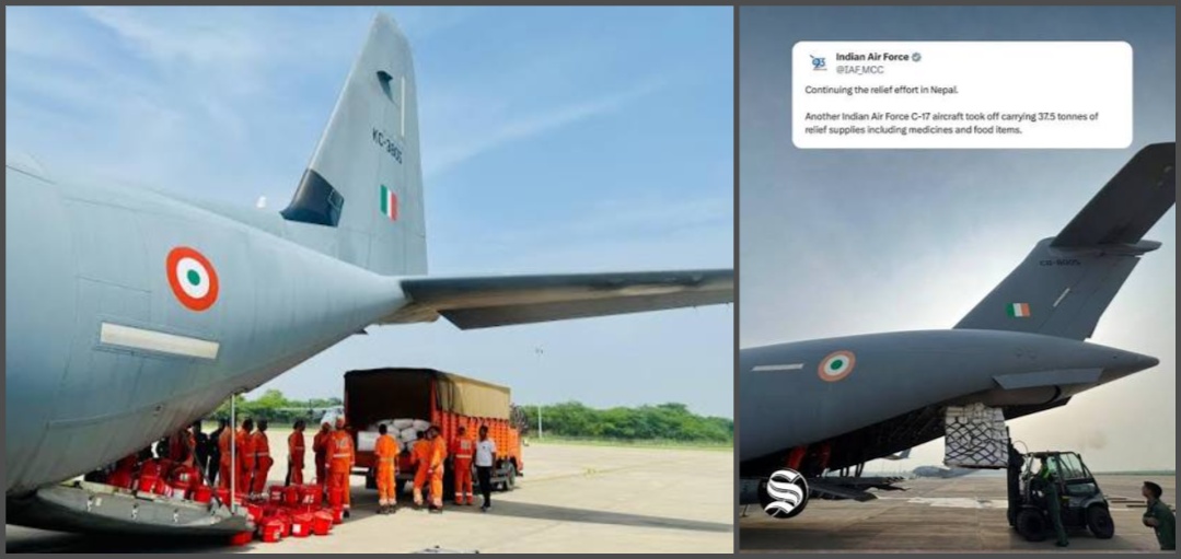
Relief material bound for Nepal being loaded on Indian Air Force C-17 Globemaster aircraft, three of which were delivered in Nepal
An Indian medical team of doctors and paramedics and a reconnaissance team were also sent, while India offered National Disaster Response Force support and prepared tunnel-rescue expertise.
These actions are important because the disaster presents India with two interconnected responsibilities: protecting Indian citizens and supporting Nepal’s recovery. The first is consular; the second is geopolitical and humanitarian. Yet the larger challenge is prevention.
Himalayan risk governance
The lesson for India should not be that it needs more helicopters after every Himalayan catastrophe. It needs better information before catastrophes occur.
At the heart of the transformation will be the need for India, Nepal and China to establish a genuinely functional Himalayan hazard-monitoring architecture covering glaciers, glacial lakes, landslide-prone slopes, river discharge and extreme precipitation.
Satellite observations should be combined with ground sensors and community-level monitoring. Data that can save lives should not become hostage to the normal rhythms of diplomatic communication.
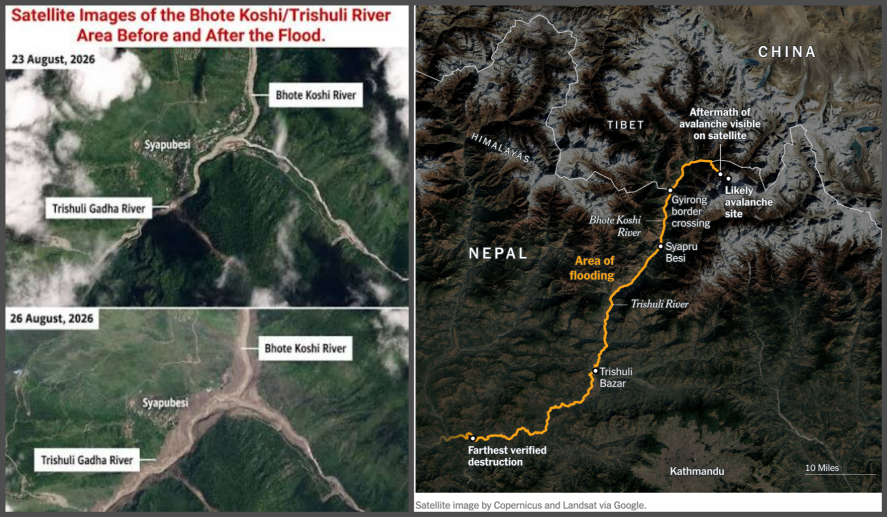
This is particularly urgent because the political boundaries of the Himalayas do not correspond to the boundaries of physical risk. A glacier may collapse in Tibet, a flood may destroy Nepal, and the resulting river surge may threaten India.
Conventional sovereignty is territorial; climate risk is hydrological and glacial. India should therefore push for real-time transboundary early-warning arrangements for major Himalayan River systems.
Such mechanisms need not resolve every political dispute between India, Nepal and China. They can begin with narrowly defined humanitarian objectives: rainfall, river levels, glacial-lake instability, landslide dams and emergency warnings.
India should also rethink the engineering standards governing Himalayan infrastructure. Historical flood records are increasingly inadequate where climate and cryosphere conditions are changing and changing fast.
New roads, tunnels, bridges, and hydropower projects should be assessed against cascading scenarios rather than isolated hazards. The relevant question is no longer simply whether a bridge can withstand a particular flood. It is whether the road-bridge-river-settlement system can continue functioning after a sequence of landslide, flood, debris flow and power failures.
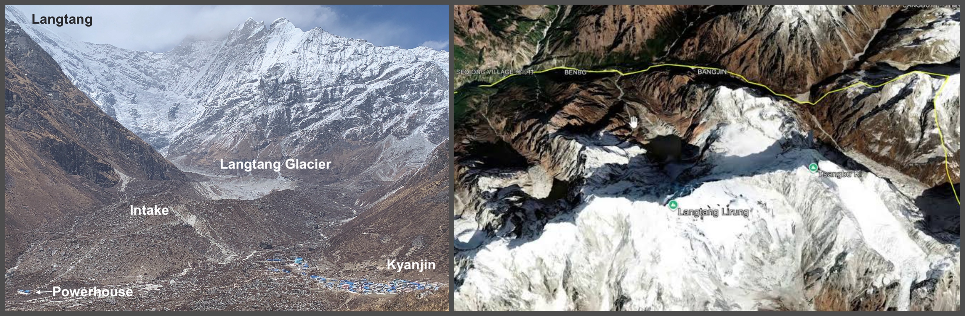
An avalanche on the Langtang Glacier (photo taken by Kunda Dixit, Nepali Times on the left, and satellite image shared on Wikimedia Commons on the right) is supposed to have caused the flash floods
The same principle applies to pilgrimage and tourism. Kailash, Mansarovar and other Himalayan trekking routes should incorporate dynamic hazard information, emergency communications, traveller registration and evacuation protocols.
The enabling environment to travel through high-risk landscapes must be matched by a corresponding capacity to locate and rescue people when conditions suddenly deteriorate.
Geopolitics of the cryosphere
The deeper significance of Nepal’s catastrophe lies in what it reveals about the relationship between climate change and international politics.
For centuries, states treated mountains as fixed geographical facts. Borders were drawn across them; rivers were engineered through them; roads and dams were built around assumptions of physical stability. The Anthropocene is weakening those assumptions.
The Himalayas are not merely India’s water tower, Nepal’s tourism asset or China’s high-altitude frontier. They are a shared risk system as well. This now demands a conceptual shift in India’s neighbourhood policy.
Himalayan cooperation should increasingly be treated as an element of national security, human security and regional diplomacy simultaneously. Disaster management cannot remain a domestic policy confined within national borders. It is becoming an instrument of foreign policy.
India’s current response — consular coordination, humanitarian assistance, medical support, rescue expertise and downstream preparedness — is an important beginning. But the real test will be whether this crisis produces an institutional response and such cooperation remains operational after the television cameras leave.
The most important lesson from the Nepal floods is not that the Himalayas are dangerous. Himalayan societies have always known that. The new reality is that the nature of Himalayan danger is changing faster than the institutions designed to manage it.
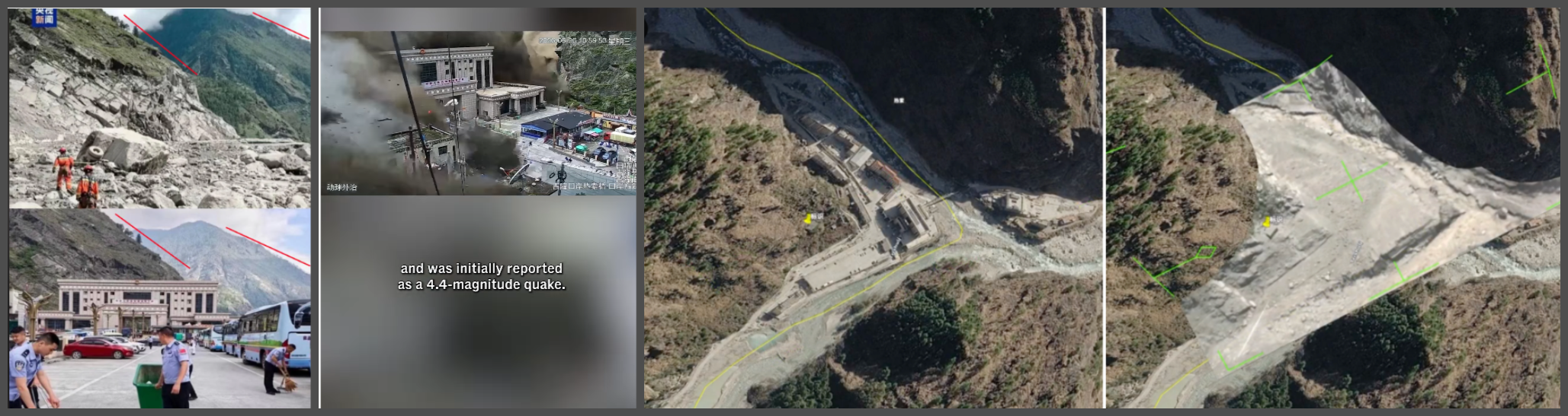
Images of before and after the flash floods hit the Gyirong Land Port
A glacier does not wait for a diplomatic note to pass hands. A landslide does not respect a territorial boundary. A river does not recognise national sovereignty.
India, Nepal and China, therefore, face a shared strategic imperative: they must move from disaster response to disaster anticipation, from national monitoring to regional early warning, and from infrastructure designed around yesterday’s climate to infrastructure capable of surviving tomorrow’s.
The mountains are moving. The question for Himalayan nations is whether their institutions can move fast enough as well.
Follow us on WhatsApp
Follow us on Facebook
Follow us on X @vudmedia
Follow us on Substack

